An Introduction to the Bitterroot Valley
- Madeline

- Mar 30
- 9 min read
Updated: Mar 31
It's taken me quite some time to figure out where to start with this blog series. I have so much to say, but the natural starting point just hasn't made sense. In the end, I decided the logical beginning should be...at the beginning. Let's take a deep dive into the history of the Bitterroot Valley and what makes it special today.
Location
Located in the western edge of Montana, the Bitterroot Valley is defined as a roughly 95 miles (from north to south) valley from just south of the city of Missoula to Lost Trail Pass, Idaho. It is bordered on the west by the Bitterroot Range and to the east by the Sapphire Mountains.

Lewis & Clark
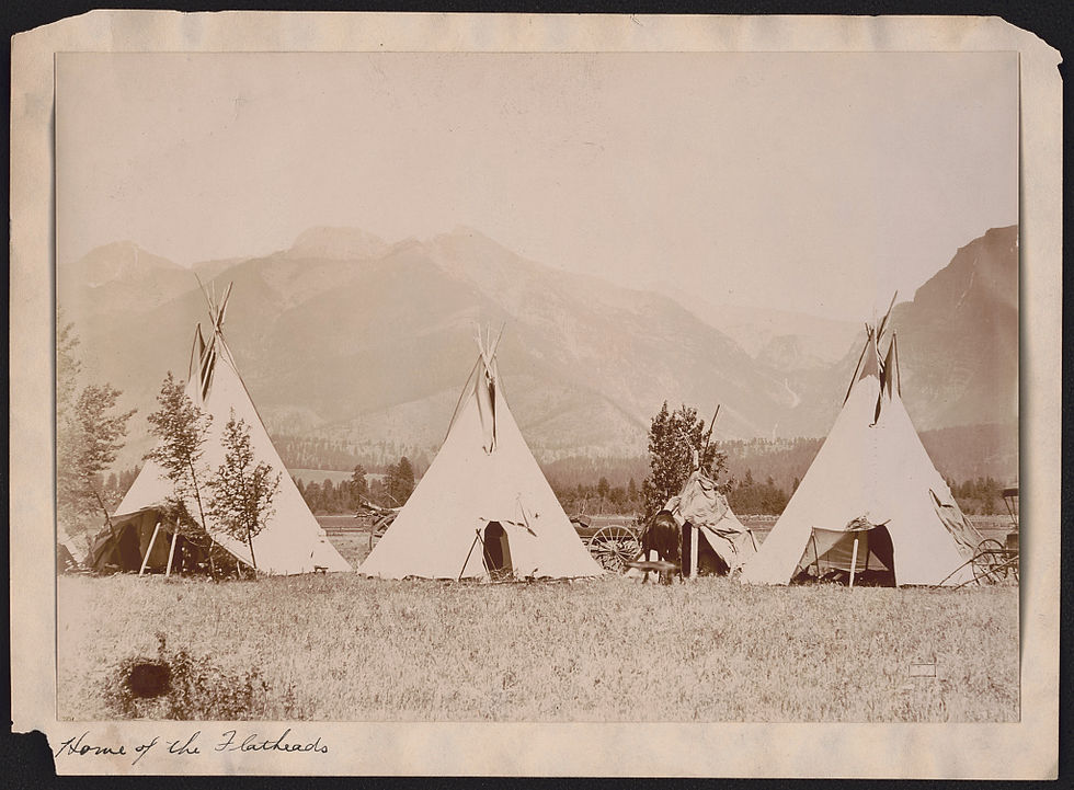
Long before this area was populated by early American settlers, this was the ancestral homeland of the Salish (modern-day Flathead) and the Pend d'Oreille Tribes. The trajectory for the land dramatically changed when Lewis and Clark found their way here in 1805, as they journeyed west on their famous expedition. The Louisiana Purchase did not include the Bitterroot Valley, although it did include most of the eastern two-thirds of what would later become the state of Montana. The Bitterroot Valley of today became US territory with the 1788 Oregon Country Acquisition.
In early September 1805, Lewis and Clark entered what is now the Bitterroot Valley and journeyed north along the modern-day Bitterroot River to the Nez Perce Trail and Lolo Creek. They famously camped at Traveler's Rest (the only archeologically verified campsite of the expedition) before beginning the hard journey through the mountains.
On September 13 of 1805, the Lewis and Clark Expedition was journeying along the Lolo Trail, which spans the modern mountainous divide between Montana and Idaho. They followed along Pack Creek (then called Glade Creek), and camped overnight in an open meadow. The explorers camped and rested in the same meadow on their return journey back east 10 months later in June of 1806. Lewis described the area in his journal as "a pretty little plain of about 50 acres plentifully stocked with quawmash and from appearances this fromes one of the principal stages or encampments of the indians who pass the mountains on this road."

Quawmash, now known as camas, had been carefully cultivated in the meadow for generations by the Nez Perce people. From the perspective of the expedition, the meadow had magically transformed from green to purple. They had arrived just before the summer bloom, whereas their journey west brought them through after the harvest. Camas has an edible root system that grows well in marshy, mountainous regions. The flats were and still are abundantly filled with the plant after careful tending by the Nez Perce.

St. Mary's Mission
The Salish were friendly towards the Lewis and Clark Expedition, and provided them with food and supplies, guiding them through the mountainous terrains as the group continued west. Sometime after this, Christian missionaries began to venture into the valley, many of whom were converted Iroquois. Belgian Jesuit Father Pierre DeSmet and five missionaries permanently moved to the valley in 1841 and established St. Mary's Mission. This is the first established church and pioneer settlement in Montana, located in present-day Stevensville.
A few years later, Fr. Anthony Ravalli (does that name sound familiar?) arrived after being recruited from Italy by Fr. DeSmet. Also a Jesuit priest, Ravalli became Montana's first pharmacist, physician, surgeon, architect, engineer, and sculptor. Ravalli built the first grist mill and saw mills, and served at St. Mary's Mission from 1845 to1850 and from 1866 to 1884 when he died. Ravalli County was named after him in 1893. St. Mary's Mission Chapel, Ravalli's log cabin, and the pharmacy have been restored and you can visit today.
The long-term impact of St. Mary's Mission and the missionaries cannot be overstated. In addition to the obvious contributions Ravalli made himself, the missionaries also introduced structured farming and animal husbandry and, of course, Christian teachings.

Fort Owen
Shortly after St. Mary's Mission was established, John Owen arrived in the valley in 1850. He purchased land from the mission and established Fort Owen. Owen took over the work the Jesuits had started with the mission, and expanded the mills, cultivated fields, and turned the area into a regional trading post.
Owen served as an official agent to the Flathead Nation from 1856 to 1862, and married a Shoshone woman. For about a decade, the Fort was a vibrant center of trade for traders, travelers, missionaries, settlers, and the native peoples. However, by the late 1860s trade dwindled, and the Fort was sold in 1872. The site operated as a shadow of its former self for many decades until it was donated to the state of Montana in 1937. By that point, the only remaining building on site was the adobe East Barracks built in 1857. Over the years, the University of Montana has excavated the original fort walls and foundations, which you can see today when you visit.

Flathead Reservation
The Flathead Reservation was first established by the Hellgate Treaty of 1855 for the Bitterroot Salish, Upper Pend d'Oreille, and the Kootenai tribes. As part of the treaty, the tribes ceded over 20 million acres of their ancestral territory over to the US in western Montana and northern Idaho, in exchange for an allotment of their own land that would be free from US government intervention.
The reservation is comprised of about 1.3 million acres including the southern half of Flathead Lake, and recognized the sovereignty of the tribes to govern their lands, resources, and people. By 1872, the US Government began to put heavy pressure on the Salish to leave and head north to the Flathead Reservation. The remaining natives in the valley faced a bleak future by 1891, and those holding out finally went north.
However, due to land allotment that began in 1904, over half a million acres of the reservation is now owned by non-tribal members. The Flathead Allotment Act allowed for large tracts of tribal land to be divided into individual parcels and available for purchase. This has created a checkerboard of tribal and private land ownership across the original boundaries of the Flathead Reservation.
Today, the tribes occupying the Flathead Reservation prefer to be called the Confederated Salish and Kootenai Tribes or CSKT for short.
Marcus Daly
Another major shift in the 19th century came in the form of copper, a copper king to be precise. In the 1880s copper mining was booming and Butte, MT became the world's largest producer of copper. One of the biggest names in the business was Marcus Daly. Daly was born in Ireland but came to the US as a young lad. He worked his way west and joined in the gold rush at Virginia City, Nevada and first major discovery of silver in the US at the Comstock Lode in 1860.

While working as a superintendent at a copper mine for the Walker Brothers in Butte, he estimated there was much more ore to be found in the hill at large and urged his employers to purchase the Anaconda Mine, which was then a mine for silver. When they didn't, he did, and made his fortune in the large deposits of copper.
You may be wondering why all of this talk of Butte and Anaconda. Well, if not for the success Daly had in those towns, Daly never would have purchased land in the Bitterroot Valley and kick-started an age of development not yet seen in the valley.
Daly and his wife Margaret purchased 22,000 acres of land in the Bitterroot in 1886. He established his summer residence there and also created the Bitterroot Stock Farm, a ranch and horse breeding facility. At one point, Daly owned 1,200 horses! His horse ranch, as you can imagine, was quite an operation and he established the town of Hamilton in order to provide services for his ranch staff and a community for them to live. He invested in infrastructure, building major roads and providing capital to get some local businesses started.

Even after his death in 1900, Marcus' wife Margaret continued his legacy of investing in the Bitterroot Valley. She donated land for the library and built the Daly Memorial Hospital. The Daly Mansion was completed in 1912. Generations of the Dalys continued to live at the mansion until the final heir deeded the mansion and the grounds to the state in 1986. The Daly Mansion Preservation Trust was founded and the mansion was open to the public the very next year.

Bitterroot Towns
From north to south along the Bitterroot River, Highway 93, and Eastside Highway, a number of towns dot the valley. They are: Lolo, Florence, Stevensville, Victor, Corvallis, Hamilton, Darby, Conner, and Sula. All except Lolo (in Missoula County), are located in Ravalli County.
Hamilton is the largest town and the county seat of Ravalli, despite the fact that it is not the oldest town in the valley. That claim to fame goes to Stevensville, founded in 1841 with the establishment of the St. Mary Mission. The name Stevensville was adopted in 1864 in honor of the territorial governor Isaac Stevens, killed in 1862 during the Civil War. Stevensville was the original county seat from 1893, when the county was established, until 1898, when it was moved to Hamilton.

Where did the name "Bitterroot" Come From?
All of this text and we haven't even discussed where the name "Bitterroot" came from?! The flower has been important to this region of Montana for generations of Salish, Flathead, Kootenai, Shoshoni, and other local tribes. The root was harvested in the spring and was often dried and saved for consumption in the winter when food was scarce.

As you can imagine, the taste is bitter, and so the roots were often cooked with berries and meats. The dried roots were so important to native peoples, that they were used as a means of trade. The Salish name for the Bitterroot flower is spetlum, but the name bitterroot became the common name after Lewis described the taste after he collected a specimen of the plant in the summer of 1806.

In honor of Lewis, the scientific name for the bitterroot flower is lewisia rediviva. The original specimen he collected near Traveler's Rest still exists and is at the Academy of Natural Sciences in Philadelphia. Over time, the valley became closely associated with the flower and the name Bitterroot was widely adopted. The Clark River running through the valley was renamed the Bitterroot River. The mountains along the western edge of the valley were named the Bitterroot Mountains, and the flower was even adopted as the state flower of Montana in 1895.

Bitterroot National Forest
Three years after the bitterroot became the state flower, the Bitter Root Forest Reserve was established. After the formation of the US Forest Service in 1905 by President Theodore Roosevelt, the reserve was transferred to the new government entity in 1906. The original acreage was then expanded and renamed the Bitterroot National Forest in 1908.
Today, the Bitterroot National Forest comprises approximately 1.6 million acres of land in Montana and Idaho, and is home to the largest continuous wilderness in the continental US. This vast wilderness is comprised of the Selway-Bitterroot Wilderness, Frank Church-River of No Return, and the Anaconda Pintler Wilderness.

The highest peak in the national forest is Trapper Peak, which stands at 10,157 feet and can be summited via an 8-mile hiking trail. This is one of many trails contributing to the more than 1,600 miles of trails in the forest. Not sure if I will ever hike them all, but I can sure try!

Now What?
Now that you know all about the Bitterroot Valley, follow along as we take a deep dive into specific trails, restaurants, town life, community events, local history and legends, and so much more. Thanks for being here.


Comments